Wednesday, January 6, 2016

Marcella Vivrette Smith Park


Back in November I ventured out to Marcella Vivrette Smith Park, Brentwood’s largest park. I went once with the family, and a second time with just me and my faithful furry companion, Gus.  My first trip out with the family was more of a scouting trip as we hadn’t really done our research on trail length and difficulty, and our son complained of being “tired” after just a few feet of setting out on the trail.  We turned around shortly afterwards because there’s nothing that ruins a day faster than having to carry a whining, 40-pound child through the woods. 


On my second time out, I picked a crisp, sunny weekday and opted to hike the perimeter trail with Gus.  It’s a relatively short trail (a little over 2 miles), but is the perfect length for a quick escape to the woods with your dog.  It takes you through a nice mix of forest and fields, and if you take the strenuous spur to Enid’s Eryie Point trail, you are treated to a hilltop view of the surrounding valley.  Gus stopped to sniff at just about every tree so it really forced me to slow down and actually take in my surroundings, as opposed to just pushing through as I usually do when hiking.  After our slow, but rewarding journey we split a PB&J back at the trailhead.


Located off Wilson Pike, Smith Park is also home to historic Ravenswood mansion, built in 1825.  After my hike, I spent quite a bit of time exploring the grounds and imagining what Nashville and the surrounding area looked like in the early 1800s (much less traffic!).  To learn more about Marcella Vivrette Smith Park, visit the City of Brentwood’s webpage.

Tuesday, December 22, 2015

Santa Claus, Arizona


There are a number of Santa or Christmas theme tourist attractions across the country. Many of them are located near mountains (I'm thinking of North Pole, Colorado near Colorado Springs and Santa's Land near the Smokies) and many were found along old US Highways where, in decades past, thousands of travelers would be pestered by their kids to stop.

A few years back, Jessica and I were heading back to Vegas from a road trip through the desert and we passed by Santa Claus, Arizona along US Highway 93.  The site of this abandoned tourist attraction compelled me to do a u-turn to check it out.  The main building is still visible and apparently it was once home to a restaurant, motel and a place where kids could mail letters to Santa. There are also the remains of an old Santa's train out front as well. It is now covered in weeds and there is graffiti everywhere.

Arizona Highways Magazine did a brief history of the attraction on their site recently. It's worth checking out if you've ever passed by this place in between Kingman and Las Vegas, or if you're simply interested in this sort of Christmas-themed tourist attraction from the past.

Wednesday, December 2, 2015

Old Car City USA


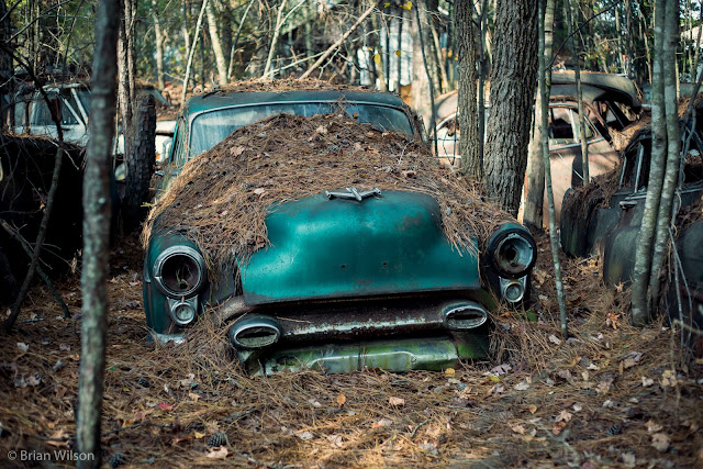
There's no doubt that man has made an impact on the natural environment, but sometimes I like to think about nature fighting back.  And at Old Car City USA, the Georgia Pines are fighting like hell.


A few months ago, Brian heard about Old Car City USA through a photography class and as fate would have it, I saw an online article about it around that same time. Located in White, Georgia, Old Car City USA purports to be the oldest known junkyard in the US, dating back to the 1930s. It's 35 acres (or 6 miles of trails) of historic American cars slowly returning to the Earth. No longer a functioning junkyard, Old Car City USA is now a photographer's dream.


Over Thanksgiving weekend, we drove down to Atlanta to visit family and made a side trip up to Old Car City USA.  As soon as we pulled into the parking lot, I knew this was going to be an awesome experience based on the marriage of art, history, and engineering all in one place. We walk in to the main garage covered in spray painted phrases and are immediately greeted by the owner. Brian pays the $25 fee to take photos while Ben and I pay the $15 to just look around.


We exit the garage and it was like stepping into a rusted wonderland full of cars that you've seen in movies and in books, but never in person.  Hudsons, Plymouths, Chevrolets....you name it.  Some were in decent enough shape that you could look inside and see the old gas pedals, radios, speedometers, and metal door locks, but most were covered in pine needles with trees growing through them.


Our three year old son, Ben, was in awe.  He would run from car to car shouting "Look at this Old Car!"  "Mama- come look inside this one!"  At one point he found a headlight on the ground and you would have thought he found a treasure chest full of gold.


Since Ben was with us, we didn't get to fully explore the property, but I foresee future expeditions to Old Car City USA.  In addition to acres of old cars, there is also a good smattering of old bikes, dolls, car parts, and other junk.  The upstairs part of the garage has a "doodle room" full of shelf after shelf of styrofoam cups colored in various patterns with black or blue pen.  It's oddly beautiful.


While I'm happy to report that nature is winning the battle, I hope that Old Car City USA stays around a while.  I'm not through exploring its treasures.


Old Car City USA is located in White, GA just northwest of Atlanta. It's an easy trip off I-75 to reach it. For hours and additional information, check out their website here.

Click here to see more photos from this amazing place.

Friday, November 6, 2015

Blue Ridge Parkway - North Carolina


The Blue Ridge Parkway is a 469 mile road that runs from Virginia to North Carolina. The entire length of this road is a National Park and as such it's the country's longest linear park. All along the way there are various pull-offs and trails to enjoy beautiful views, walk to waterfalls, and hike up to the top of mountains for incredible vantage points. In this blog post we'll explore a few sites along the Parkway near Asheville, NC.

Devil's Courthouse


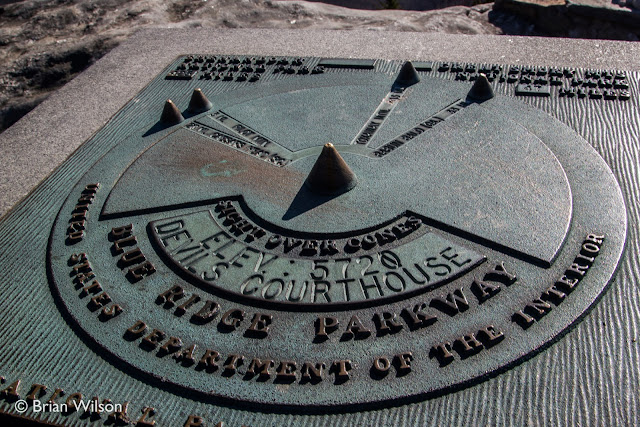
Sitting at an elevation of 5720, Devil's Courthouse is an impressive looking mountain that offers a commanding view of the Blue Ridge Mountains. A relatively short (1/2 mile) and slightly strenuous trail leads to the rock-exposed top of the mountain. The mountain's look was thought to be sinister by some and local lore suggested that the devil himself may "hold court" deep inside the mountain. Unfortunately we could not confirm nor deny this rumor to be true.


From the top you can see four states. I'm leaning towards believing this claim to be true unlike the one made by those murderous gnomes at Rock City.

Rock City's infamous Murderous Evils (*probably not murderous)

The view is certainly impressive and on good visibility days you can see for miles. An interesting marker bolted to a rock points out some of the peaks visible nearby.

Looking Glass Rock


Another landmark along the Blue Ridge Parkway, near Asheville, is Looking Glass Rock. This 4,000 foot mountain is seen from several vantage spots along the parkway. From the Parkway, Looking Glass Rock looks like a rock climber's dream. On the other side there is a 3-mile (one-way) slightly less vertical hike up to the top. Also near here is Looking Glass Falls which looks absolutely beautiful and will definitely warrant a visit from us on our next trip to this area. For more information about Looking Glass Rock, check out this page.


Craggy Gardens


Taking the Blue Ridge Parkway northeast of Asheville brings us to Craggy Gardens. This area is known for exposed rock and wildflowers, particularly the rhododendron thickets that dominate many parts of the trail. We visited here in November, so the rhododendrons were not blooming but their empty thickets were impressive to walk through. I imagine the tunnel of rhododendrons would be impressive in the spring.


The cold day and slightly-threatening clouds made for an interesting trip to the top of this heath bald. There was no one else up here on this day, so the vacant hiking shelter and the total lack of other human beings made for a slightly creepy atmosphere.


There are also impressive views to be found up here. Craggy Gardens definitely stands out as a great place to stop to experience the varied landscapes and environments found along the Parkway.


Mt. Mitchell


When I was a kid I remember the shocking disappointment of learning that Clingman's Dome, the highest point in Tennessee in the Smoky Mountains, was NOT the tallest mountain in the Eastern United States. That title belongs to Mt. Mitchell, a peak found in the Black Mountains just northeast of Asheville. The mountain tops out at 6684 feet and it offers a panoramic view of the Pisgah National Forest and surrounding mountains from the observation tower on top.


Mt. Mitchell is the featured attraction of Mt. Mitchell State Park. In this park you'll find hiking trails, a gift shop, the all important restrooms and even a full service restaurant with nice views. Note: Because of the altitude it is always considerably cooler (or colder) up here than down in Asheville. The altitude also creates an alpine-like environment with the types of trees and plant life found here. There is no admission fee charged, so this is a free visit and well worth it. You can find out more about Mt. Mitchell State Park here.

Little Switzerland


Little Switzerland is located about map's center


Between Mt. Mitchell and Linville Falls, and just off the Blue Ridge Parkway, is the resort town of Little Switzerland, NC. This town is home to a wonderful place to grab something to eat called the Switzerland Cafe. They are noted for their barbecue and offer a full menu of great things to eat. It's definitely worth checking out if you find yourself there around a meal time.

Note: the cafe is only open "in season" meaning they close sometime in November and open back in in the Spring. Be sure to check out the site before planning to go there.

Linville Falls


Required viewing for anybody traveling along this part of the Blue Ridge Parkway is Linville Falls. The main falls drops over 90 feet in to the Linville Gorge and the main trail offers multiple vantage points of the falls. Before you even get to the overlooks for the main falls you get a nice view of the smaller, but still impressive Upper Falls.


The park is also filled with beautiful hardwood trees, so it's particularly beautiful in the fall. There are other trails that lead to different vantage points of the gorge and falls, plus there's access down in to the gorge itself and provides an up close view of the falls from the base.


Nearby you'll find Linville Caverns and Grandfather Mountain, both popular attractions offering different perspectives of the geography and geology of the area.

These are just a few of the many places to stop along the southern end of the Blue Ridge Parkway. For more information about the Blue Ridge Parkway, you can check out their official site.

Saturday, October 24, 2015

Top 10 Hikes in Chattanooga

View from a Lula Lakes Trail

RootsRated just put up a great list of some of the best hikes in the Chattanooga area. A couple of those hikes we can vouch for: Lula Lakes and the Cloudland Canyon West Rim Trail. The others look like must-dos and it's a reminder of just how much scenic beauty surrounds the Chattanooga area.

Cloudland Canyon


To check out the list, go here. To check out our report on touring Lula Lakes, go here.

Thursday, September 17, 2015

Sewanee Natural Bridge and Grundy Lakes State Park


Sherwood, TN and the Cumberland Plateau

A beautiful fall day is a great opportunity to explore the Cumberland Plateau of Tennessee. On this day we journeyed to the southern portion of the Plateau around the towns of Sewanee and Monteagle. The trees had yet to turn but the air was crisp and the skies were deep blue with nice fluffy clouds. Every direction you looked seemed like it would make for an awesome photograph.

Sewanee Natural Bridge


First stop was the Sewanee Natural Bridge which is located just south of Sewanee off State Route 56. There is a small parking area and a trail that descends down to the top of the bridge. The trail continues across the actual bridge and then descends further into a sinkhole. Note: While not particularly dangerous or strenuous, it is important to be careful as you cross the natural bridge and descend down in to the sinkhole.


The natural bridge is 25 feet high and spans almost 50 feet. A wet spring found here is believed to have slowly eroded away the sinkhole and formed the natural bridge. If you go under the bridge there is a short trail you can take to further observe nature's work with towering cliffs on one side and large boulders to scramble over or walk in between. Along the trail you can see limited views down in to Lost Cove which lies just below the natural bridge. Lost Cove is home to Buggytop Cave which has one of the most impressive cave entrances in the state. You can hike to Buggytop Cave by a trail that leaves the Carter State Natural Area just south of Sewanee Natural Bridge.


Found around the sinkhole are a number of carved signatures left by visitors long ago (some believed to have been left in the 1880s). According to an article on nooga.com, a historian researched the names and did not find that they were locals, thus indicating the natural bridge probably served as a popular roadside attraction for a number of years. The natural bridge would have been a relatively short detour off of US 41A. The area does seem relatively free of modern vandalism.


Climbing out of the sinkhole

Sewanee Natural Bridge is part of a larger collection of parks called the South Cumberland Recreation Area. In this system you will find canyons, waterfalls, lakes and caves to explore. Savage Gulf is one part of this system and you can check out a post we made about it here. Grundy Lakes State Park is another part of this system which we also visited on this day.

Grundy Lakes State Park


Grundy Lakes State Park

Near Tracy City, TN, you will find Grundy Lakes State Park. The area was devastated by coal mining and in the late 1930s the CCC (Civilian Conservation Corps) transformed the land in to what you see today complete with lakes, trails and trees. Almost of all of the natural beauty present here is thanks to the efforts of the CCC.


There are a few hiking trails here including a nice loop around the lake. The park also offers access to the lake for swimming and fishing. The remains of coal mining past are still seen all over the park as well. The most visible reminders are the 100+ coke ovens found along a number of the trails in the park.

Coke Ovens

The coke ovens were used to convert coal in to industrial coke that could then be used as fuel for the smelting of iron ore. Note: The main trail tends to take you behind the coke ovens. The view from here is less impressive as the openings tend to be much smaller. In a few places it's possible to actually walk in front of the ovens to see them like in the picture above. Also, in many places you'll notice that the trail itself consists of coal. It makes for an interesting crunching sound as you walk over it.

Coal on the trail

The Cumberland Plateau, while utterly beautiful, has been mined and clear-cut so often over the years that it's amazing there's anything of beauty left. Places like Grundy Lakes State Park remind us that beauty can be reclaimed from manmade devastation.  In a future post we'll highlight a little bit more about some of the mining operations on the plateau.

Wonder Cave


Finally, we decided to drive US 41 north to head back to Nashville. Doing this means taking a windy descent off the plateau. The road is particularly steep indicating the road was built before the more modern, and less steep, standards of today. At the foot of the plateau you'll find the old sign for Wonder Cave, a once popular tourist attraction that suffered with the advent of the interstate system.

Wonder Cave Entrance Building

A few years ago Jessica wrote a little post about Wonder Cave and we decided to take a quick swing by the old building. The place is locked up so you can't explore the property nor see the cave, but it was good to finally see the grounds in person. For years I have heard of Wonder Cave and while I've always had a deep fascination with caves, Wonder Cave is the only modern Tennessee commercial cave that I never got to visit. It would be great to one day explore the cave if it ever were to open back up.

South Cumberland State Recreation Area map

For more information about the South Cumberland State Park, including Sewanee Natural Bridge and Grundy Lakes State Park, check out their page here.